Highway 88 Trails
Learn more about the HWY 88 CorridorTrails of the Highway 88 Corridor
Carson Pass Area
Winnemucca Lake – Easy
2.3 miles one way
Hiking, equestrian
Perhaps one of the most popular hikes in the Carson Pass area is the trek from Carson Pass to Winnemucca Lake. With a gradual climb to granite expanses and alpine lakes, it is a great trail for families. From the Carson Pass trailhead, the trail rises gently through the red fir forest to Frog Lake at approximately 1 mile. It’s small but a great place for a break and snack before continuing on through high and often flower filled alpine meadows to Winnemucca Lake. Nestled at the base of tall granite cliffs, Winnemucca Lake is a high-sierra experience – alpine wildflowers, bald mountains, summer snow patches, and fresh air without a strenuous hike. Try for a weekday to avoid the crowds and remember to keep your pooch on a lease in this area.
Options: Continue to Round Top Lake, Round Top Mountain, Woods Lake, Fourth of July Lake or make a loop to return to Carson Pass.
 Devil’s Ladder – Strenuous
.5 miles one way
Hiking
For the history buff, the hike down Devil’s Ladder follows the route of the thousands of gold seekers and others that came to California between 1849-1851 on the Mormon Emigrant Trail. This section of the trail is where emigrants had to use block and tackle to haul their wagons up the slope. From the Red Lake Overlook, walk down the Amador/Nevada Wagon road about 125 feet looking for the historic trail markers on several of the trees to the left of the road. Hike down the ladder looking for wagon ruts and trees with scarring from the ropes and chains used to haul the wagons.
Options: Continue down the trail to Red lake or start at Red Lake and hike up the Amador – Carson Valley Wagon Road.

Meiss Meadow – Moderate
Hiking, equestrian
3 miles one way
Looking for a hike to take with your dog? Meiss Meadow is a great place to explore and your dog can explore too. Start at the Meiss Trailhead just west of Carson Pass. Follow the trail skirting a grove of Jeffrey Pines and up a hillside covered with mules ears and sagebrush to Meiss Col for great views of the surrounding peaks – Elephants Back, Round Top, The Sisters and more. A little further descend into a broad meadow and cross the headwaters of the Upper Truckee River. To the left you will find the remnants of a summer range for cattle with an old line cabin, corral and barn. The meadow is perfect for lunch.
Options: Continue to Meiss Lake, Showers Lake, Round Lake or Echo Summit.
Caples Lake Area
 Lake Margaret – Easy
2.4 miles one way
Hiking, biking (Note, several steep rocky areas challenging to navigate), equestrian
A great family hike follows Caples Creek to small Lake Margaret where you can picnic or fish. Begin at the Lake Margaret trailhead near Caples Lake. The trail begins in lodgepole pines and hemlocks, on through a granite landscape and back into trees again. At 0.7 mile it reaches the bridge that crosses Caples Creek. Alternating between forests and rocky landscapes watch for the variety of flora – corn lily, cow parsnip, and expanses of lupine until you reach the shore of the granite shored lake with rock islands. Take time for a picnic or plan on spending the night.
 Schneider Camp
Schneider Camp is one of the lesser know locations in the greater Carson Pass/Meiss Country area. The slope is at a lower elevation than that south of Carson Pass (Round Top/Winnemucca areas), consequently the trails are clear earlier in the Spring and the flowers in the Schneider Camp area generally bloom earlier than those south of Carson Pass.
Trails leaving from Schneider Camp
Meiss Ridge (9140′) – Moderate
1.5 miles one way
Showers Lake via Meiss Ridge (8647′) – Moderate
3 miles one way
Showers Lake via PCT north around Little Round Top Mtn (8647′) – Moderate
7.3 miles one way
PCT Junction (8960′) – Moderate
5.5 miles one way
Little Round Top Mtn from the north via trail to PCT (9590′) – Moderate
4 miles one way
Echo Summit via PCT (7240′) – Moderate
15.7 miles one way
Schneider Camp Loop Hike: Schneider Camp -> Little Round Top Mtn -> Showers Lake -> Meiss Ridge -> Schneider Camp
Approximately 5.8 miles of moderate hiking.
To get to the Schneider Camp Trailheads
From the Carson Pass Information Station, drive west about 3 miles on Highway 88 to the paved road on the right side of the highway. The road leads into the CalTrans Maintenance Station. Turn onto this road and drive to the station.
At he gate and stop sign at the Maintenance Station, turn left and drive along side of the gray building. The road is paved to just past the building. From there the road is a bladed county road that is sometimes maintained. Continue driving up the bladed gravel road to the horse trailer turnaround area. There are dispersed camping sites along this road. Often the area will be congested with horse trailers. An old corral to your right as you approach this location.
Continue driving past the horse trailer turnaround area for an additional 0.4 miles to the end of the road and the Schneider Camp parking area and trailheads. The road after the horse turnaround area becomes very rough and rocky. Low clearance vehicles should park here and walk to the end of the road.
At the end of the road at Schneider Camp, there are three trailheads. Starting on the north side of the parking area the trail goes north and then east around Little Round Top Mountain to a junction with the PCT. To the east is the trail to Meiss Ridge and Meiss Country. The third trail, the 4-WD track, goes to Kyburz. Do not let the appearance of the 4-WD track near the parking area fool you; it gets much worse.
Kirkwood Area
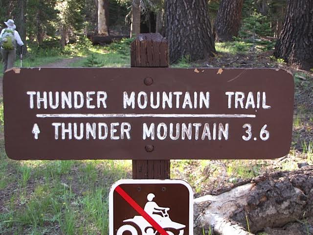
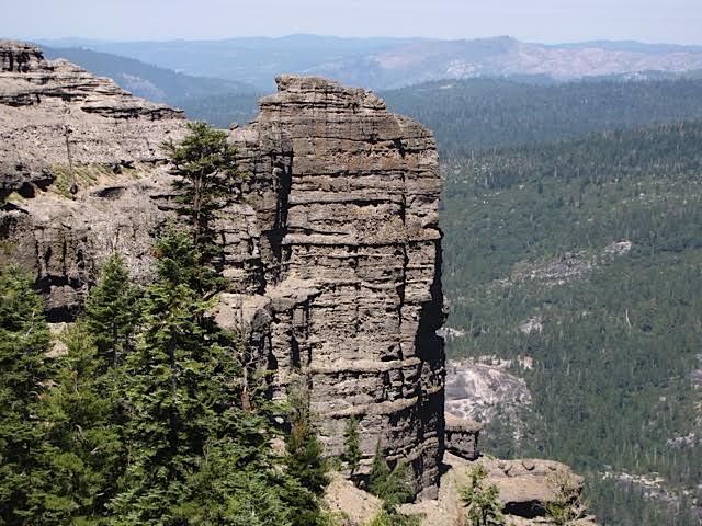
Thunder Mountain – Strenuous
3.6 miles one way
Hiking, biking, equestrian
Want great views, the Thunder Mountain trail offers some of the best! The trail begins at the Thunder Mountain trailhead between Silver Lake and Kirkwood. You hike steadily up hill through tall trees until you reach the top of the ridge near Two Sentinels, volcanic outcroppings. Here you will see strange structures looming over the highway below. These “jet roots” help reduce the buildup of snow on the edge, reducing avalanche hazard. Continue on along the ridge to Martin Point enjoying the views to the north of Pyramid Peak and Kirkwood. At 3.2 miles continue to the right on the trail to Thunder Mountain for great views of the Silver Lake area. You’ll feel like you are on top of the world!
Options: For a longer hike, take the 1.6 miles connector trail at the junction to the Horse Canyon Trail. Then follow the Horse Canyon Trail for 2.2 miles back to Highway 88. This can also be made into a loop by following old Highway 88 to Martin Meadow, then the Castle Point Trail back to the Thunder Mountain trailhead.


Silver Lake Area
Shealor Lake – Easy
1.4 miles one way
Hiking
A short hike, the Shealor Lake trail offers outstanding views, and rugged alpine scenery. The trail is in and out up and down. From the trailhead, it rises for 0.5 miles, then down a steep granite slope with 12 long switchbacks, making it relatively easy. Reach the lake, a deep hollow in a bed of solid granite. At one end there are vertical granite cliffs rising high above the water, while the other end has camping and picnicking opportunities. Swimming is a pleasant option.
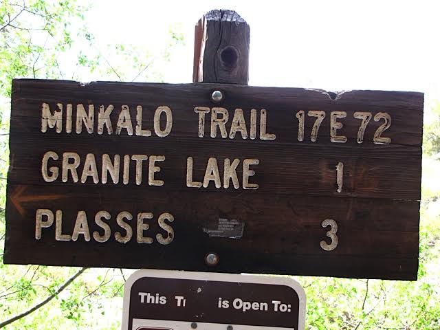
Granite Lake – Easy
1 mile one way
Hiking, biking, equestrian
Looking for a short but scenic hike? This 2.0 mile round trip begins on a rocky trail passing lodgepole and Jeffrey pines. The path crosses over a glaciated area where giant boulders are scattered across the landscape. Watch for ducks (stacks of rocks) to keep track of the trail. A junction marks the trail to Plasse ‘s Resort. Continue straight to Granite Lake. Pass through manzanita, canyon live oak, Jeffrey and lodgepole pines and mountain hemlocks before you arrive at the shore. Enjoy the deep water of this midsized lake.
Option: For a longer hike continue on to Hidden Lake.

Blue Lakes Area
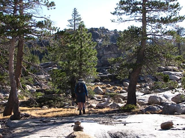
Granite Lake – Moderate
2.0 miles one way
Grouse Lake – Strenuous
5.0 miles one way
Hiking, equestrian
Both these lakes are reached by the same trail. You can make it a short hike to Granite Lake or continue on to Grouse Lake or somewhere in between for a longer hike. The trailhead is located just beyond the Middle Creek Campground. You will ascend gradually upward through the forest to a dry rocky landscape. At 1.3 miles you will pass a small pond and begin a brief climb. At 2.0 miles you will arrive at Granite Lake, surrounded by wildflowers. Stay here for a picnic, or continue on toward Grouse Lake. Even if you don’t want to go the entire distance, the views from the ridge of the North Fork of the Mokelumne River and Meadow Lake to the right and Raymond and Reynolds Peaks and Evergreen Lake to the left are worth the extra effort.
PO Box 908, Placerville, CA 95667
(530)303-8344 | infoSPAMFILTER@enfia.org
Quick Links
Explore
PO Box 908, Placerville, CA 95667
(530)303-8344 infoSPAMFILTER@enfia.org